|
2020 Global & Galaxy Links
|

Mars Ruins – Explain This!
Since the beginning of 2020, a YouTube channel has been posting a series of videos titled “Mars Ruins – Explain This!” The premise of the channel is that a devasting explosion destroyed an ancient Martian civilization. To prove the theory, the folks at the channel meticulously scan images of Mars looking for evidence. As of September 18, 2020, they had posted 25 video scans.
Most of their videos would never convince a skeptic that the fragmented pieces strewn over the planet’s surface are the remains of an ancient civilization. However, the one above from Episode 3 is not so easy to dismiss. It looks like a broken lintel from over a door or window. Compare it to the ancient Incan entranceway in the photo below.
The Mars Ruins – Explain This! video series is posted on the “Oasice On The Fly” YouTube channel. Each episode is about five minutes long.

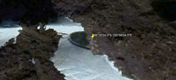
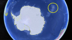
ANTARCTICA: Disc-shaped object in melting ice
By Mary Joyce, website editor
The ice in Antarctica is melting fast because of record-breaking high temperatures. On February 9, 2020, the thermometer at one research station recorded 69.3°F which is an all-time record for the continent.
Needless to say, ice melts fast at nearly 70 degrees and never-before-seen objects are being uncovered that cannot readily be dismissed as natural geological formations. The photos above reveal one of those objects. It is about 60 feet in diameter and appears to have a raised rim around its circumference.
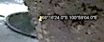
Over the years, we’ve noticed multiple photo strips within a small area of satellite maps often appear after objects or activities have been discovered on Earth or Mars that the public is not supposed to see. The photo below may be an example of this. The yellow marker shows the location of the above disc.
You can check out the object for yourself by copying the following coordinates and then pasting them in your Google Earth search bar. Once there, you may need to rotate the image to get the proper perspective of the disc-shaped object.
66°16'24.0"S 100°59'04.0"E |
Mystery energy particles blast out of Antarctica
By Mary Joyce, website editor
Three times since 2016, ultra-high-energy particles have blasted up through the ice of Antarctica, according to a January 24, 2020 article on the Live Science website.
The article presents possible explanations for the blasts but none fit our known understanding of physics “no matter how you slice it,” says Anastasia Barbano, a University of Geneva physicist involved with the IceCube Neutrino Observatory in Antarctica.
IceCube is designed to search the cosmos for neutrinos which are subatomic particles with practically no mass. But ultra-high-energy particles originating from Earth baffle scientists.
This begs the question, what’s going on beneath Antarctica?
 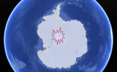
IceCube Neutrino Observatory (L) is located in the center of the red blast on the Antarctica map.
It is the first detector of its kind designed to observe the cosmos from deep within the icy continent. |
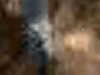
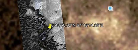
Photo evidence of Mars structure cover-up
By Mary Joyce, website editor
Above is another Mars image we found that reveals perpendicular lines and box shapes that suggest intelligently designed structures. It’s impossible to determine if it’s an ancient ruin or a contemporary structure but the sharp angles might suggest the latter. Whichever it is, it’s big. Both the widest and longest lines are about two miles in length.
We found the above image sometime in the middle of February 2020, but found it obliterated (below) when we returned to the image on February 20, 2020. A strip of totally different terrain had been added on the left half of the image and the right half had been blurred into oblivion. Even though we used the very same Google Earth Mars coordinates (8°48'50.32"N 67°18'14.06"E), the only thing that remained the same was the little blue square in the right half of the image.
|
Another HAARP-like weather manipulator
By Mary Joyce, editor
Years ago, I met an elderly man who was involved in the creation of HAARP technology which manipulates the Earth’s ionosphere and thus the weather. He said it originally was intended to be an instrument for bloodless warfare. An enemy nation, he explained, could be destroyed with droughts, hurricanes or floods with little or no blood being lost.
Well, a lot of destruction and lost lives have resulted from Earth’s weather being manipulated by HAARP. Maybe that’s why HAARP maps ceased to be available to the public after 2015. Well, there’s another HAARP-like global network.
MEET HAARP’S COUSIN: The Super Dual Auroral Radar Network, nicknamed SuperDARN, is an international scientific radar network consisting of 35 high-frequency radars located in both the Northern and Southern Hemispheres. Like HAARP, its focus is the ionosphere.
I stumbled upon SuperDARN when I was using Google Earth to explore Port-aux-Francais on a tiny French island somewhat near Antarctica. What I discovered was something that looked a bit like a HAARP array just east of the island’s only town. Then I learned about SuperDARN.
Google image of Super Dual Auroral Radar on French island near Antarctica (L)
Photo of a known SuperDARN in Saskatoon, Canada (R)
To find the French island’s SuperDARN for yourself, copy and paste the following coordinates into the search bar at Google Earth: 49°21’01.83”S 70°15’57.31”E |
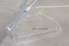
Could this be a HAARP array in Antarctica?
By Mary Joyce, website editor
Once upon a time, anyone could see daily HAARP frequency maps on their computer. When those frequencies spiked, then intense weather events soon followed. Below are sample HAARP maps from the past showing intense energy before three notable storms. Sadly in 2015, those daily maps became unavailable to the public.
  
HAARP maps before Hurricane Sandy, Snowstorm Nemo, Snowstorm Leon
Even though HAARP maps no longer can be found, there is every indication that HAARP arrays still are in operation. And, we may have found one in Antarctica that the public doesn’t know about. In fact, a Google Earth satellite camera may have photographed it when it was turned on or fired up because it is so intensely bright.
 
|
 |
ABOVE: A possible HAARP array is circled along with a zoomed-in photo of it.
LEFT: a HAARP array in Alaska when it was not being fired up.
To find the possible array in Antarctica, copy and paste theses coordinates into the Google Earth search bar:
70°12'28.17"S 87°57'15.04"E |
|
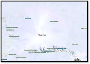 |
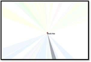
This only happens at the South Pole
We’ve used Google Earth to zoom in and out of uncountable places on the planet. But when we did this at the South Pole, there was an unexpected burst of pale colors. Could this be indirect confirmation that there’s something the public isn’t supposed to see at the South Pole? - The editor |
 |

|
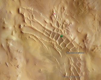
Ancient box-shaped ruins on Mars
By Mary Joyce, website editor
Could these box shapes on Mars be remnants of walls from an ancient civilization? It’s hard to believe wind or water could have created them. Indeed, they would destroy, not create, perpendicular lines. Neither have we found similar “geology” near this site.
The boxes within this formation are quite large. The smallest one is approximately a mile square. The largest is about 2 x 2.5 miles in size.
Yes, we’ve seen satellite photos of this formation before but never with location coordinates.
We had to do a major scan of the planet to find it. If you would like to find the possible ancient ruins for yourself, go to Google Earth and click on the planet icon at the top of the screen. Then copy and paste these coordinates in the search bar:
81°26'31.73"S 63°48’52.46”W
|
Puzzling structures recently found in deep space
Scott Waring, a dedicated deep space watcher, discovered three unique objects in the dim, distance and little-known Caelum Constellation in the Southern Hemisphere. He found them in late November 2019 when using the Worldwide Telescope. The first thing that caught his eye was a disc-shaped blue object within the gold circle in the first image below. An enlargement of the blue object is on the right. In some ways, it looks like a satellite dish.
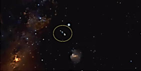 
Next, he noticed something above the blue disc that he speculated might be a wormhole because of its funnel-shaped top and a tube-like tail that seemed to go on forever. Notice all the dark blue dots within this object in the third image below.
  
Then below the disc, he found an amorphous object that also included straight edges. Again, notice all the dark blue dots within it.
 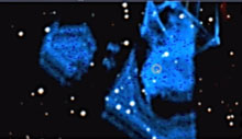
Scott Waring’s YouTube channel is ET Data Base. |
|
|